In short
Allow at least two full days in Cusco, and start gently: most travellers get used to the altitude in a few days. Day 1, at your own pace: the Plaza de Armas, the cathedral, Hatun Rumiyoq street, San Blas, then the Qorikancha. Day 2: Sacsayhuamán and the sites above the city, included in the Boleto Turístico. The Qorikancha temple, the cathedral and Machu Picchu each have their own ticket.
Two cities, one on top of the other
Cusco is at about 3,400 m, in a valley in the southern Andes. In the 15th century, the Inca Pachacútec made it the capital of an empire that soon stretched from present-day Ecuador to central Chile. The chroniclers report that the city had been designed in the shape of a puma, with the fortress of Sacsayhuamán as its head; this is a tradition reported after the conquest, not a plan that has been found. In the centre, the rulers’ palaces surrounded a huge square, and the main temple, the Qorikancha, was covered with sheets of gold.
Francisco Pizarro entered the city in November 1533. The Spanish did not raze it: they built on the Inca foundations, whose cut stone, fitted without mortar, was sturdier than anything they knew how to build. The Santo Domingo convent rose on the Qorikancha, the archbishop’s palace on that of the Inca Roca, the city’s first church, El Triunfo, on the palace of the Inca Viracocha. The earthquakes of 1650 and 1950 destroyed a large part of the colonial city; the 1950 earthquake exposed the Inca walls of the Qorikancha, which had been thought lost. UNESCO listed the city in 1983.
In practice, you can see it on every street corner: the lower part of the walls, in polished blocks with perfect joints, is Inca; the upper part, in rougher stone, adobe or plaster, with wooden balconies, is colonial or republican.
A walk from the centre to San Blas
Half a day, at a slow pace, with breaks. Distances from the Plaza de Armas: Qorikancha 600 m; San Blas square 600 m, uphill; San Pedro market 800 m; Sacsayhuamán 1.4 km, steeply uphill.
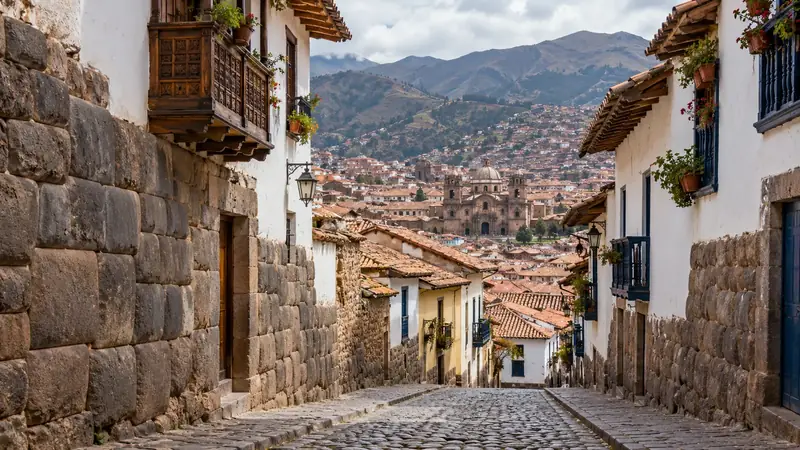
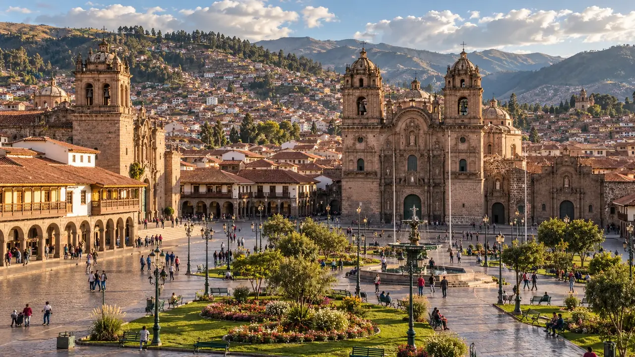
- The Plaza de Armas. This was the great Inca ceremonial square, Haukaypata. The cathedral, built from 1560 to 1664, and the chapel of El Triunfo, the city’s first church (1539), line it, as does the Church of the Society of Jesus.
- The cathedral. It holds a large collection of paintings from the Cusco School, one of the great centres of painting in colonial America, where Indigenous and mestizo painters blended European subjects with local realities: a Last Supper there shows a cuy in the middle of the table. It is part of a religious circuit run by the archdiocese, with its own ticket.
- Hatun Rumiyoq street. The long wall of the archbishop’s palace is the former wall of the palace of the Inca Roca; this is where you look for the famous twelve-angled stone. Do not touch it: in February 2025, a man struck it with a hammer, causing irreversible damage.
- San Blas. The craftspeople’s quarter, on the hillside, climbs through narrow streets and stairways to a square and a small church. On the little Plaza de las Nazarenas, on the way, the Museum of Pre-Columbian Art (MAP) presents about 450 pieces from the collection of Lima’s Museo Larco, in a colonial mansion built on an Inca building.
- The Qorikancha. Head back down towards Avenida El Sol. The Inca rooms preserved in the Santo Domingo convent and, outside, the great curved wall give a measure of what the Temple of the Sun was. The site museum, beneath the gardens, is another place, with another ticket.
- San Pedro market. Finish at the central market, south-west of the square: fruit juices, soups, Andean breads and cheeses, and a glimpse of daily life. Keep an eye on your belongings.
Before buying a jumper, a scarf or a poncho, at San Pedro, in San Blas or in the shops of the centre:
Museums and temples: who sells which ticket?
| Place | What you see | Ticket |
|---|---|---|
| Qorikancha temple (Santo Domingo convent) | The walls of the Incas’ main temple within a colonial convent | Its own ticket, sold on site |
| Qorikancha site museum | Archaeological collections, beneath the gardens | Boleto Turístico, circuit II |
| Cathedral, San Blas and San Cristóbal churches, archbishop’s palace | Colonial architecture and painting | The archdiocese’s religious circuit, sold on site |
| Museum of Pre-Columbian Art (MAP) | Ceramics, gold and silverwork and textiles from all of ancient Peru | Its own ticket |
| Regional History Museum, Museum of Contemporary Art, Museum of Popular Art, Centro Qosqo de Arte Nativo, Pachacútec monument | Regional history, popular arts, traditional dances | Boleto Turístico, circuit II |
| Sacsayhuamán, Q’enqo, Puka Pukara, Tambomachay | The Inca sites above the city | Boleto Turístico, circuit I |
The full Boleto Turístico costs S/ 130 for 16 sites, valid for 10 days; a single circuit, S/ 70. Details of the sixteen sites and buying tips on the Cusco and the Sacred Valley page.
Sacsayhuamán and the sites above the city
Sacsayhuamán, at about 3,700 m, overlooks the city. Its three zigzag walls, made of enormous blocks fitted without mortar, earn it the name of “fortress”, but the place also had religious functions; the chronicles attribute its construction to Pachacútec and his successors. Every 24 June, the esplanade hosts the re-enactment of Inti Raymi, the Festival of the Sun.
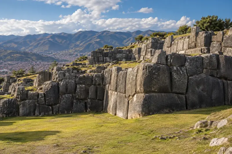
Higher up, on the road to Pisac, three other sites complete circuit I:
- Q’enqo, a great sacred rock (huaca) carved with channels, steps and an underground chamber, probably linked to rites and the cult of the dead.
- Puka Pukara, the “red fort”, a post that controlled the road to the Antisuyu, the Amazonian part of the empire.
- Tambomachay, a series of fountains and channels fed by springs, nicknamed the “Inca’s bath”; its exact function remains uncertain.
The most pleasant way is to take a taxi up to the highest point and walk back down: Plaza de Armas–Tambomachay 8.9 km by road; walking back Tambomachay–Sacsayhuamán 5.2 km, then 1.4 km to the Plaza de Armas, almost all downhill. Allow half a day to a day depending on your pace; the sun is strong, and rain is frequent in the afternoon in the wet season.
Where to stay: slopes, noise and access
| Area | Advantages | Limits |
|---|---|---|
| Around the Plaza de Armas | Everything on foot, on the flat or nearly | Noise from bars and festivals, higher prices |
| Towards Avenida El Sol and the Qorikancha | Flatter streets, easy access by car | Less charm, traffic |
| San Blas | Views, relative quiet, craft workshops | Steep stairs and slopes, difficult access by car |
| San Cristóbal, above the square | Views over the city | A daily climb, to avoid in the first few days |
| Wanchaq and newer neighbourhoods | Gentler prices, neighbourhood life | Far from the historic centre on foot |
For the first nights, choose accommodation that can be reached by car, without an endless flight of stairs to the door, and ask whether it is heated: the nights are cold from April to September, during the dry winter, with night frosts. The FDFA recommends caution at night in the centre, booked taxis rather than those hailed in the street, and reports frequent demonstrations and blockades in Cusco and on the roads to Machu Picchu.
For booking, Booking (hotels, hostels) and Airbnb (apartments) cover Cusco well: read the recent reviews on heating, hot water and access. We also have contacts in Peru: write to us if you would like an opinion or an address.
Two, three or four days
Arrival day. Nothing other than a slow walk around the Plaza de Armas, a light meal, water. If you are arriving directly from Lima by plane, consider going down to sleep in the Sacred Valley and coming back to Cusco afterwards.
Two days. The walk above, then Sacsayhuamán and the circuit I sites.
Three days. Add a day of museums and neighbourhood life: the MAP, San Pedro market, a show of traditional dances at the Centro Qosqo de Arte Nativo (times posted on site).
Four days. Add Tipón and Pikillaqta to the south-east (circuit II) or, if you are well acclimatised, a day trip to Vinicunca, the Mountain of 7 Colours, or to Palcoyo: see Vinicunca and Palcoyo.
If the altitude is still weighing on you, do not add a climb just to stick to the programme: rest for one more day. If you feel unwell and it gets worse instead of passing, go back down and see a doctor. See altitude.
From the airport and to the Valley
A Cusco provider publishes indicative prices per vehicle (up to four passengers, according to the provider) for the airport, Urubamba and Ollantaytambo station: they appear in the table below, with the date they were recorded. These are neither per-person prices nor an average for Cusco drivers, and the provider is neither tested nor a partner: ask for a quote for your dates, and divide by the number of travellers to compare with a per-person offer.
Eating in Cusco
Cusco’s cooking is high-altitude cooking: potatoes and corn in every form, thick soups, dried meats, fresh cheeses. A few pointers:
- Cuy (guinea pig), a domestic animal of the Andes, is eaten oven-roasted or flattened and fried (chactado); it is often ordered whole, to share. See Where to eat cuy?
- Chiriuchu, a cold festive dish, brings together cuy, chicken, dried meat, sausages, a corn cake, fish roe and seaweed; it is eaten in June, above all for Corpus Christi, not all year round.
- Humitas, fresh corn dough cooked in its husk, for breakfast or as a snack.
- Soups, served as a starter in almost every midday menú.
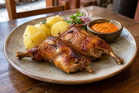
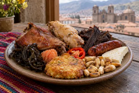
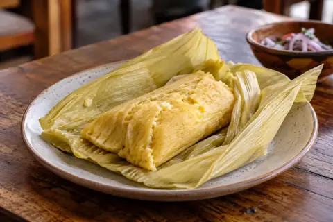
At midday, neighbourhood menús (starter, main course, drink at a fixed price) are the simplest way to eat like the locals; San Pedro market serves juices and soups from the morning. See also Andean cooking.
Frequently asked questions
Is the Qorikancha included in the Boleto Turístico?
Not the temple itself, preserved in the Santo Domingo convent, which has its own ticket. The Boleto Turístico includes the Qorikancha site museum, located beneath the gardens: these are two different visits.
Can you walk up to Sacsayhuamán?
Yes, from the Plaza de Armas, in about twenty minutes on paper, via very steep streets and stairs up to around 3,700 metres. In the first few days, take a taxi up and walk down.
Where should you stay in Cusco if you cope badly with altitude?
In the historic centre, on the flat around the Plaza de Armas and towards Avenida El Sol, rather than at the top of San Blas or San Cristóbal, where every return trip means climbing stairs.
Sources and dates
11 sources
Prices, opening hours and rules change: every piece of information cited links to its source, with the date it was consulted.
Figures and rules cited
- about 3,400 m: Altitude of Cusco (centre) (Cusco) . Wikidata gives 3,399 m, the CDC about 3,350 m: the city spreads over several tens of metres of height.
Press or reseller: Wikidata, Cuzco (Q5582862), altitude (new tab) · consulted on 1 October 2026 - Qorikancha 600 m; San Blas square 600 m, uphill; San Pedro market 800 m; Sacsayhuamán 1.4 km, steeply uphill: Walking distances from Cusco’s Plaza de Armas (Cusco) . The calculation takes neither the slope nor the altitude into account.
Press or reseller: Walking routes calculated on OpenStreetMap (FOSSGIS routing server, pedestrian profile) (new tab) · consulted on 2 October 2026 - S/ 130 for 16 sites, valid for 10 days: Full Boleto Turístico del Cusco, foreign adult visitor (Cusco and the Sacred Valley) (Foreign adult (S/ 70 for a foreign student))
Site management: COSITUC, Boleto Turístico del Cusco (new tab) · consulted on 1 October 2026 - S/ 70: Partial Boleto Turístico del Cusco (one circuit), foreign adult visitor (Cusco and the Sacred Valley) (Foreign adult) . Circuit I: four sites above Cusco, 1 day. Circuit II: eight museums and sites including Tipón and Pikillaqta, 2 days. Circuit III: Pisac, Ollantaytambo, Chinchero and Moray, 2 days.
Site management: COSITUC, Boleto Turístico del Cusco (new tab) · consulted on 1 October 2026 - about 3,700 m: Altitude of the Sacsayhuamán site, above Cusco (Sacsayhuamán, Cusco)
Press or reseller: Wikipedia (English), Sacsayhuamán (3,701 m) (new tab) · consulted on 2 October 2026 - Plaza de Armas–Tambomachay 8.9 km by road; walking back Tambomachay–Sacsayhuamán 5.2 km, then 1.4 km to the Plaza de Armas, almost all downhill: Sites above Cusco (circuit I): distances (Cusco) . Q’enqo and Puka Pukara are on the way; the calculation takes neither the slope nor the altitude into account.
Press or reseller: Routes calculated on OpenStreetMap (FOSSGIS routing server, car and pedestrian profiles) (new tab) · consulted on 2 October 2026
Sources consulted
- Inacal, checking labels and origin for a safe purchase (16 June 2026) (new tab) (consulted on 7 October 2026)
- Inacal, technical standards for artisanal weaving and embroidery, labelling (1 March 2022) (new tab) (consulted on 7 October 2026)
- alpaca.ch (a Swiss seller of alpaca clothing), fibre categories (“baby alpaca”) (new tab) (consulted on 7 October 2026)
- UNESCO, City of Cuzco (new tab) (consulted on 2 October 2026)
- COSITUC, Boleto Turístico del Cusco (new tab) (consulted on 2 October 2026)
- Wikipedia (English), Cusco, Coricancha, Cusco Cathedral, Sacsayhuamán, Q’enqo, Tambomachay, twelve-angled stone (new tab) (consulted on 2 October 2026)
- Wikipedia (English), Museo de Arte Precolombino, Cusco (new tab) (consulted on 2 October 2026)
- PROMPERÚ, six typical dishes of the Andes (2 July 2020) (new tab) (consulted on 2 October 2026)
- CDC, travel to high altitudes (new tab) (consulted on 25 September 2026)
- FDFA, Conseils pour les voyages – Pérou (travel advice, in French: Cusco) (new tab) (consulted on 1 October 2026)
- Travel Inkas Route, indicative private transport prices (new tab) : prices published by the transport company, with no commercial link to SwissLima. (consulted on 26 September 2026)
How we choose and date our information: our method. Has something changed? Let us know.