
In short
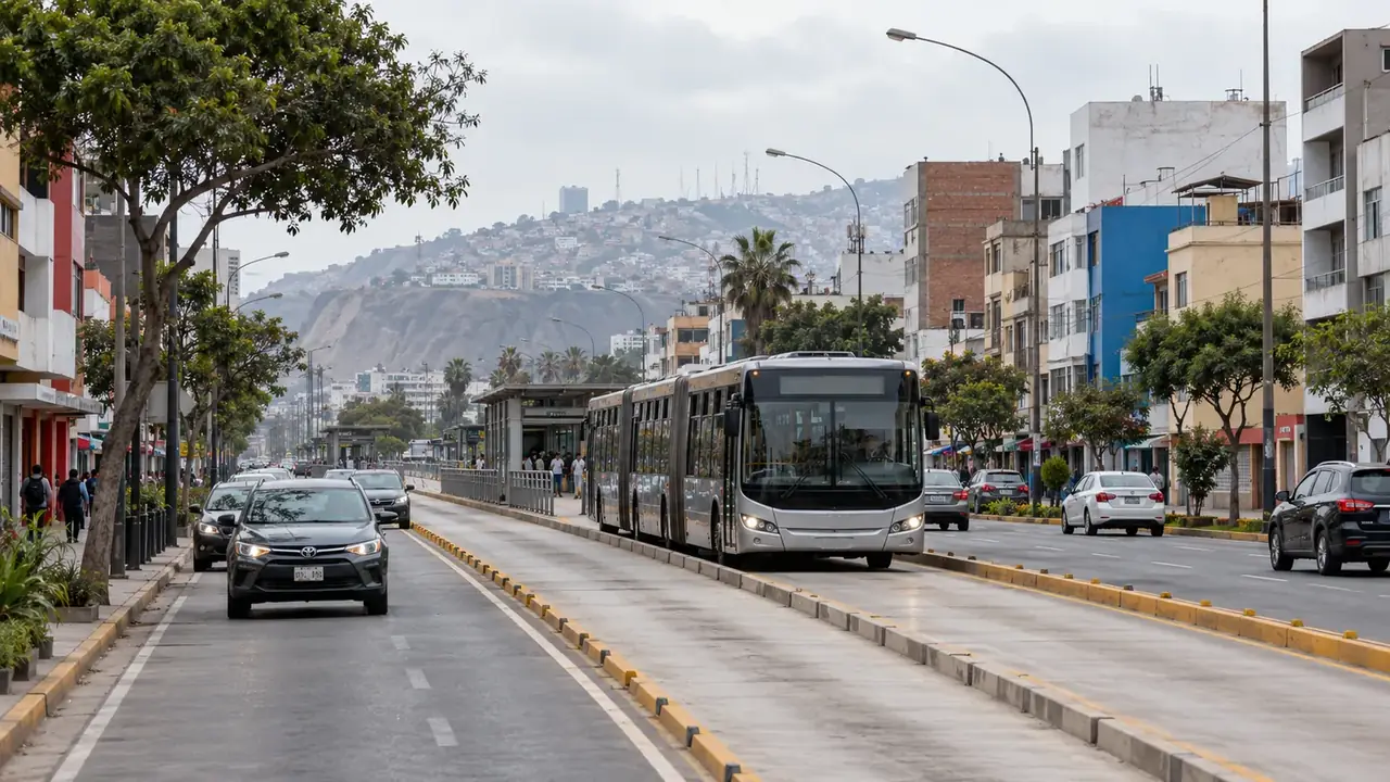
Between Miraflores, Barranco and the historic centre, the Metropolitano (bus rapid transit, top-up card) is the fastest at rush hour; the Corredor Azul follows Avenida Arequipa. Metro Line 1 is useful for Gamarra and San Borja, not for Miraflores. For Pueblo Libre, Callao or a journey with luggage, a taxi booked through an app or by the hotel is still the simplest option. Group your visits by area: that is the real time saver.
The principle: one area per half-day
The most visited neighbourhoods are far apart: there are about 9.5 km by road between Parque Kennedy, in Miraflores, and the Plaza Mayor, and about 10 km to the Museo Larco, in Pueblo Libre. These distances are modest; it is the traffic that makes them long, especially in the late afternoon on weekdays.
The rule that saves the most time is therefore not a network but a way of organising things: one area per half-day, starting from your accommodation. The historic centre and Rímac in the morning, Pueblo Libre another half-day, Miraflores and Barranco on foot the rest of the time. Do not plan to cross the city just before a booked dinner or a bus departure.
Five networks not to confuse
| Network | What it is | Useful for | Does not serve |
|---|---|---|---|
| Metropolitano | Articulated buses on dedicated lanes, from the north (Chimpu Ocllo terminal) to the south (Matellini terminal, Chorrillos), along the Paseo de la República urban expressway | Miraflores, Barranco ↔ historic centre; avoiding traffic jams | Pueblo Libre, Callao, the airport |
| Metro Line 1 | A metro that is largely elevated, from Villa El Salvador (south) to Bayóvar (north-east) | Gamarra (Gamarra station), the Gran Teatro Nacional (La Cultura station), the eastern centre (Miguel Grau station) | Miraflores, Barranco, the colonial centre within walking distance of the Plaza Mayor |
| Corredor Azul | Regular bus lines on Avenida Arequipa and the Tacna–Garcilaso axis | Miraflores ↔ centre at street level, more frequent stops than the Metropolitano | Pueblo Libre, Callao |
| AeroDirecto | Public buses to the airport | The airport from the centre, Pueblo Libre, the north | Miraflores and Barranco |
| Metro Line 2 | five stations between Evitamiento and Mercado Santa Anita, in eastern Lima, opened on 21 December 2023 | Of little use for a tourist stay today | The historic centre, the airport |
Paying: cards and fares
- Metropolitano and Corredor Azul: top-up card (Lima Pass or Metropolitano card), sold and topped up in the stations. A journey on the Metropolitano’s main line costs S/ 3.20. On the Corredor Azul, the press reported in August 2026 a fare of S/ 2.40 for two journeys.
- Line 1: a card specific to the metro, S/ 5 excluding credit, then S/ 1.50 per journey at the standard fare. Hours: last departures from both terminals, Villa El Salvador and Bayóvar, around 22:00, every day, according to the operator’s FAQ; at an intermediate station, the last train depends on the direction. For an evening journey, check on the operator’s timetable page the last train at your station, in your direction and for your day; customer service hours are not the train times.
- Taxis and apps: payment in cash or through the app depending on the service. Amounts are agreed before getting in.
A card bought for one network does not necessarily work on another: ask at the ticket office, when you buy it, which networks it works on. Have small notes ready for topping up.
Typical journeys between bases
| Journey | Simple solution | Budget solution | Good to know |
|---|---|---|---|
| Miraflores → historic centre | App taxi, outside rush hour | Metropolitano from Ricardo Palma or Benavides, to Jirón de la Unión, Colmena or Estación Central | The Metropolitano avoids the evening traffic jams; at rush hour, the buses are packed |
| Miraflores → Barranco | On foot: 3.6 km, about 50 minutes to the Bridge of Sighs | Metropolitano from Benavides to Bulevar | The seafront promenade is the journey itself |
| Miraflores → Huaca Pucllana | On foot: 1.8 km, about 25 minutes | Same | Residential streets, continuous pavements |
| Miraflores → Surquillo markets | On foot: 1.3 km, about 20 minutes to No. 1, 1.8 km, about 25 minutes to No. 2 | Same | You have to cross the Paseo de la República expressway, at the designated crossings |
| Miraflores → Museo Larco (Pueblo Libre) | App taxi | City buses with a change: not very practical for a first visit | No fast network links the two; leave in the morning |
| Centre → Gamarra | Short taxi ride | Line 1 to Gamarra station | Gamarra is best visited by day, on a weekday |
| Miraflores → Callao and La Punta | App taxi | City buses with a change | Crossing the city: set aside half a day |
Taxis and apps
Lima has street taxis, company taxis (radio taxis) and vehicles booked through apps (Uber, Cabify, InDrive, among others). The FDFA advises, especially in Lima, taking only official taxis booked in advance or those provided by the hotel, because of assaults reported in taxis hailed in the street. An app or a radio taxi also gives you a record of the journey and a price known in advance.
Before getting in, check the number plate and the driver’s name; sit in the back; keep bags and phone inside, away from the open window. For a street taxi, agree on the price before leaving: there is no meter.
Walking in Lima
Miraflores, Barranco, the historic centre and Pueblo Libre are best discovered on foot once you are there. The seafront of Miraflores and Barranco, at the top of the cliffs, is one long continuous promenade. In the centre, the pedestrian streets (Jirón de la Unión, Jirón Ucayali) link the Plaza Mayor with the Plaza San Martín.
Two local habits protect your phone: checking a route before going out rather than while walking, and keeping your mobile put away at the edge of the pavement, where most of the snatchings reported by the FDFA take place (often by thieves on bicycles or motorbikes).
Accessibility
Line 1 stations are equipped with lifts. On the Metropolitano, access is via footbridges and ramps depending on the station; at rush hour, the crowds make boarding with a pushchair or a wheelchair difficult. For a traveller with reduced mobility, a taxi or a booked vehicle is often more reliable than a public network. See Travelling at your own pace.
Keeping a margin
Journey times shown by the apps vary widely from one hour to the next. For a fixed appointment (a booked dinner, a long-distance bus, a guided tour), add a wide margin at the morning and evening rush hours. For the airport, see the page Arriving in Lima.
Sources and dates
8 sources
Prices, opening hours and rules change: every piece of information cited links to its source, with the date it was consulted.
Figures and rules cited
- about 9.5 km: Distance by road, Kennedy park–Plaza Mayor de Lima (Miraflores–historic centre) . Distance only: the actual time depends on the traffic.
Press or reseller: Route calculated on OpenStreetMap (FOSSGIS routing server, car profile) (new tab) · consulted on 2 October 2026 - about 10 km: Distance by road, Kennedy park–Museo Larco (Pueblo Libre) (Miraflores–Pueblo Libre) . Distance only: the actual time depends on the traffic.
Press or reseller: Route calculated on OpenStreetMap (FOSSGIS routing server, car profile) (new tab) · consulted on 2 October 2026 - five stations between Evitamiento and Mercado Santa Anita, in eastern Lima, opened on 21 December 2023: Metro Line 2: section in service (Line 2, Ate and Santa Anita) . Extensions are announced for 2026; for now the line serves neither the historic centre nor the airport.
Press or reseller: Wikipedia (Spanish), Línea 2 del Metro de Lima y Callao (new tab) · consulted on 2 October 2026 - S/ 3.20 per journey: Metropolitano: journey on the main line (Metropolitano (ATU), Lima) (General fare)
Price recorded: ATU, 2026 publication restating the Metropolitano general fare (new tab) · consulted on 26 September 2026 - S/ 2.40 for two journeys: Corredor Azul (avenida Arequipa buses), two journeys with a connection (Avenida Arequipa and the Tacna–Garcilaso axis, between Barranco, Miraflores and the centre) (With a Lima Pass card or a Metropolitano card) . A two-way bus lane was trialled on avenida Arequipa from 6 August 2026, for 30 days that may be extended.
Press or reseller: Infobae, Corredor Azul on avenida Arequipa (3 August 2026) (new tab) , published on 3 August 2026 · consulted on 2 October 2026 - S/ 5 per card: Line 1: buying the card (Lima Metro Line 1, Lima) (All passengers) . On first use, the card plus the first journey come to S/ 6.50.
Price recorded: Line 1, fares (new tab) · consulted on 26 September 2026 - S/ 1.50 per journey: Metro Line 1: adult journey (Lima Metro Line 1, Lima) (Adult, general fare)
Price recorded: Line 1, fares (new tab) · consulted on 26 September 2026 - last departures from both terminals, Villa El Salvador and Bayóvar, around 22:00, every day, according to the operator’s FAQ; at an intermediate station, the last train depends on the direction: Operating hours of Metro Line 1 (Line 1, Villa El Salvador–Bayóvar) . First trains and times by station: the operator’s timetable page.
Old source: Línea 1, FAQ: what time do the last trains leave (new tab) · consulted on 5 October 2026 - 3.6 km, about 50 minutes: Walking distance and time, Kennedy park (Miraflores)–Bridge of Sighs (Barranco) (Miraflores–Barranco) . Automatic calculation between two points, with no breaks; the seafront route is a little longer.
Press or reseller: Walking route calculated on OpenStreetMap (FOSSGIS routing server, pedestrian profile) (new tab) · consulted on 2 October 2026 - 1.8 km, about 25 minutes: Walking distance and time, Kennedy park–Huaca Pucllana (Miraflores)
Press or reseller: Walking route calculated on OpenStreetMap (FOSSGIS routing server, pedestrian profile) (new tab) · consulted on 2 October 2026 - 1.3 km, about 20 minutes: Walking distance and time, Kennedy park–Surquillo market no. 1 (Miraflores–Surquillo)
Press or reseller: Walking route calculated on OpenStreetMap (FOSSGIS routing server, pedestrian profile) (new tab) · consulted on 2 October 2026 - 1.8 km, about 25 minutes: Walking distance and time, Kennedy park–Surquillo market no. 2 (Miraflores–Surquillo) . Automatic calculation between two points, with no breaks.
Press or reseller: Walking route calculated on OpenStreetMap (FOSSGIS routing server, pedestrian profile) (new tab) · consulted on 7 October 2026
Sources consulted
- Line 1, fares (new tab) (consulted on 26 September 2026)
- Line 1, frequently asked questions: last trains (new tab) (consulted on 5 October 2026)
- Wikipedia (Spanish), Línea 1 del Metro de Lima y Callao (stations) (new tab) (consulted on 2 October 2026)
- Wikipedia (Spanish), Metropolitano (Lima) (terminals, express services) (new tab) (consulted on 2 October 2026)
- Wikipedia (Spanish), Línea 2 del Metro de Lima y Callao (new tab) (consulted on 2 October 2026)
- ATU, a 2026 publication restating the Metropolitano’s standard fare (new tab) (consulted on 26 September 2026)
- Infobae, the Corredor Azul on Avenida Arequipa (3 August 2026) (new tab) (consulted on 2 October 2026)
- FDFA, Conseils pour les voyages – Pérou (travel advice, in French: taxis, bag and phone snatching) (new tab) (consulted on 1 October 2026)
How we choose and date our information: our method. Has something changed? Let us know.